|
Rock Climbing is abundant in Oregon with new
sites developing all the time. Smith Rock
is amazing and the birthplace of modern sport
climbing. The following are a list of
places one can climb within a short distance to
Portland.
Beacon Rock
is 35 miles east of Vancouver. The rock climbing
area of Beacon Rock is closed between February
and July for nesting raptors.
Bridge of the Gods Bouldering
is a newly developed bouldering area in the
Columbia River Gorge and is actually on the
Washington side of the river.
Broughton Bluff
is located in Troutdale. There are
numerous walls to climb:
Bat Wall, Berlin Wall, Bridge Cliff, Broken
Rock, Freeway Wall, Hanging Gardens Wall-Left,
Hanging Gardens Wall-Right, Jungle Cliff, Mean
Street, New Frontier Cliff, North Face Red Wall,
Spring Rock, The Zone, Trinity Wall, Warrior
Wall.
Take I-84 at the Lewis & Clark State Park exit
East of Troutdale. Turn south at the
T-intersection, drive beneath the railroad and
follow the climbers and to Red Wall.
Bulo Point
is close to Hood River. It has 15+ bolted
routes with at least 2 overhanging sport climbs.
Drive south from Hood River or, east from
Government Camp on Hwy 35. Between Sherwood and
Robin Hood campground turn east on F.S. 44.
Drive for about 10 miles. Turn on 4420 take it
for little more than a mile then turn left onto
4421 which leads to 240. Stay right, take this
for about 1 mile. Look for a trail on your left.
Park and hike 2 min on the trail to crag.
Carver Bridge Cliffs
requires that you are a member of the Carver
Climbing Club. To become a member, you must pay
$8.00 for life and sign a waiver at the Portland
Rock Gym. From I-5 North/South in the
Portland area, take the I-205 North exit and
proceed toward Clackamas. From I-205 North take
Exit 12 and head East on HWY 212 toward Mt.
Hood. From HWY 212 take HWY 224 South which
takes you right into the town of Carver. Once in
Carver, the road will split. Stay to the right
and cross the river. Once over the bridge,
take a left and park in the immediate dirt
pullout on the right side of the street. The
trail leads right up from the pullout. If for
some reason the pullout is full, you must park
in the park that is a quarter mile down the road
on the left-hand side. There is free parking
here during the week, but weekends and holidays
pose a $3 charge.
French Dome
is a small crag. It is located near Mt. Hood.
Most of the routes are bolted and the height
ranges from 80ft to 160ft. Take US 26
east/Mounthood Highway. Pass through the
stoplight at Welches to the intersection of US
26 and E. Lolo Pass Road. Take E. Lolo Pass Road
for 4.2 miles until the Y intersection of Forest
Road 18 and Forest Road 1828. Stay straight/left
at the fork and continue up FR 18 for 2 miles
and then make a right-hand turn into a small
dirt parking area. Then take a trail for about 1
min. to the crag.
Rat
Cave currently has 8
full lines. Travel east on I-84 to the
Bridalvale exit. Park on the south side of
Benson lake about 1 mile before Multnomah falls.
Pete's Pile
by Mt Hood offers climbs called Schoolroom
Cracks, The Playground , and The Sandbox.
Take Hwy 35 just north of the Sherwood
campground on the east side of the road. Park at
small gravel pull off and climb up a steep trail
rising to the left. It is between Sherwood and
Cooper Spur.
Rocky Butte
includes the following sections:
Boulders in the Woods, Breakfast Cracks, Dream
Weaver Wall,
Easy Street, Far East Wall, Fortress Top
of Rocky Butte, Freeway Wall, Gothic Pillars,
Mean Street, Poodle Pinnacle, Silver Bullet
Bluff, Toothpick wall,
Trivial Pinnacle, Video Bluff, Wall of Shadows,
Warrior Wall, and Wizard Wall.
Take I-84 then 82nd. Ave. exit (eastbound),
drive north to the intersection of Freemont and
82nd. Turn right (east), drive approximately 1/2
mile. The road curves north to become 91st
street, (eventually to loop clockwise around to
the top of Rocky Butte). The cliffs are located
north side of the road near the Bible Temple
Church "domes."
Rocky Butte Boulder Field
is located on a small secluded cliff called The
Schwingus. Follow the normal directions
to rocky then to reach The Schwingus, park by a
stone wall on the East side of the rock across
from the south entrance to the bible school.
Follow the trail that parallels this wall,
eventually dropping down to the freeway. When
the trail splits, follow the right fork down the
hill paralleling a chain link fence. Eventually
the trail heads right, back in the woods and in
a couple of hundred yards the small cliff will
be apparent.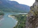
Salmon River Slab
is a slab located on the Salmon River. It's a
small area and has great river access.
Everything is bolted. The difficulty is about
5.5 to 5.9. Take 26 to Zigzag. Drive
south on Salmon River Road (F.S. 2618), for just
under 4 miles. On your left you will see a rock
slab, park in the gravel pullout.
Waterboard City Park
is near Oregon City.
Mt.
Hood Climbing
Illumination
is on Hood at about 9500ft. There are at least 5
rock climbing routes. Park at
Timberline Lodge. Hike up to top of lift and
angle toward rock. It will take 2 to 3+ hrs.
Mirror
Mountain:
Look up the ski lift and to the right from the
parking lot. There will be a twenty minute hike.
Alpine climbing on Mt. Hood:
Lethoulds Coular, Cooper Spur, and South Side.
Ice Climbing on Mt Hood:
F, P, Pp, R, Reid Glacier Headwall, S, and The
North Face.
Willamette
Valley
35th Street Dunwai Creek Bridge Bouldering Wall
is usually only climbable from mid April -
November due to the water level being too high.
From Philomath Blvd./HW 20/34, take a left on
35th St. if going west. (If
traveling east that would be a right.) Drive
down 35th street past Western View Middle
School/Adams School over the Dunwai Creek
Bridge. On your left will be Knollbrook Comunity
Church. Park in the parking lot there and
walk on over to the bridge.
Canyon Creek Cliffs
offers some good bouldering. Head east on hwy
20 from I-5 until you reach Canyon Creek and
park on the left side of the HWY. Hike north
from the east side of the creek. You will find a
small trail leading down the creek with a yellow
rope to assist in the steep part. When you get
down in the canyon turn right/north for about
100ft then turn right again and go upstream. The
cliff is on your right and there is more
bouldering a little further up the creek on the
same side.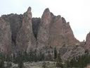
Falls City Falls
allows you to climb above water. Take HWY 20
to the sign where it says Kings Valley which is
about 15 miles west of Corvallis. Go to Kings
Valley, then to Peedee, then to Falls City where
the road zigzags. When you see the post office,
the pull off is real close on the right.
However, the best climbing is on the other side.
To get there turn right at the post office, then
left directly after that and it will be on your
left.
Flagstone
is a popular place to climb since it is close to
Eugene. Take Highway 126 out of Eugene for 38
miles. Turn right on Quartz Creek Bridge and
cross the McKenzie River. Quartz Creek Road is
FS road 2618. Stay on FS road 2618 for 14.6
miles. At 14.6 turn right on FS road 350.
Continue for .2 miles and park at the pullout.
From the pullout you'll see the trail about 50
to 100 feet up the road. (There is
camping)
Hagg Lake Road Slab. Drive to Hagg lake which is
south of Forest Grove. Before you get to
the lake, look on the right at a corner. Just
after the slab there is a locked driveway. Park
and walk on the road back to the rock.
Harlen Roadside Quarry
Take HWY 20 West from Corvallis to Burnt Woods
Road (about 22 miles). Continue on Harlan Burnt
Woods Rd until you hit the Old Harlan Store.
Turn right, stay on your right until the roads
turns to gravel. The rock is about 2 or 3 miles
down that road on the right.
Menagerie Wilderness
is a place for experts. From Sweet Home take
HWY 20 east for about 20 miles. You will see a
road on your right to Fernview Campground.
Continue on HWY 20 for about 0.5 miles after
seeing Fernview Campground and you will see
Rooster Rock Trailhead. Hike this trailhead (its
about 2.1 miles and 2,500 feet elevation gain)
until you see chicken rock.
Minto Rail Wall
offers some bouldering. It is located by
Salem.
P-IKE Boulders
is a very small bouldering area located near the
town of Yamhill.
Skinners Butte Columns
is a 45' columnar basalt cliff that has seen
climbing since the 1940's.
Wolf Rock
from Eugene, head east on Hwy 126 toward
Bend. As you are heading east, you will turn
left at the Blue Lake Reservoir turnoff. From
there you will continue on that road using the
Forest Service markers staying on Road 15.
Northeast Oregon
Anthony
Lake has granite and is
mainly for sport climbing from 5.4 - 5.10a.
Take I-84 until you reach North Powder. Once in
North Powder take USFS 73 west until Anthony
Lake.
Ashgrove
has routes that can be very steep. Take
Ash Grove cement plant exit off I-84, 20 miles
east of Baker City. Park at the turn in
for the cement plant at the silver railroad
building. Run across the freeway and start up
the hill. Hike up the draw on the
right for about 150 yards to a rock careen.
Follow the trail left to the crag. Hike
time is aprox.15 min.
Benthos Buttress
near Joseph has steep alpine granite in Scotts
Creek Cirque. Approximately 800ft.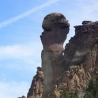
Burnt River Canyon
has four walls to climb. While some are hard to
get to the limestone sport routes are great. For
the most part the climbing is 5.11 or harder,
but there are a few easier routes. Watch our for
Rattlers and Ticks. From Durkee head
north on Old Highway 30 to Burnt River Canyon
Lane. Take a left onto Burnt River Canyon Lane
and follow for 21 miles. You'll see the areas on
your right
Eagle Creek
is a New Crag that just got opened up this
summer 2006. There are about 12 bolted lines,
maybe 8 have seen FFA. The climbing is very
technical on steep limestone.
Flagstaff Point
is quality alpine granite. Hike up to
Brownie Basin, and the climbing is around the
meadow and on the point. The Cliffs range
from 40feet to 400ft.
High
Valley has about 30 short
climbs on good quality rock. Of the approx 10
bolted routes, they range from about 5.6 to
5.12. Anchors are easily accessible for top
roping. There are rattlesnakes in the summer.
Horse Thief Butte
is a great beginner/moderate climbing area. When
it's raining in PDX it can still be dry out
here. It is very good bouldering and top roping.
From The Dalles drive 3 miles north across the
Columbia River and then 2.5 miles east on
Highway 14 to small bridge, cross the bridge and
park on the left or at state park historical
marker to the west. Hike on the path south to
the hidden amphitheater in Horsethief Butte.
Lostine River Canyon
has granite cliffs right by the road. It
is a short drive up the river from Lostine.
Mt.
Emily is a 100+ foot
cliff with about twenty bolted routes. Mostly
5.10 and up.
This one is difficult to find. It requires
about ten miles on a rough forest service road,
and then a quick hike downhill to the top of the
cliff. GPS may help.
Spring
Mountain
offers a great collection of routes very close
to the freeway with easy access for a huge
variety of climbers. On I-84 from
Pendleton, head east toward La Grande. Take the
Summit Rd./ Mt. Emily exit off of I-84. Turn
left on Summit Rd., cross over the interstate,
and proceed approximately 8 miles on a gravel
road until you see a sign on the right that says
"Whitman Route overlook". Turn left at this sign
and go about a mile to a meadow where a dirt
road angles off to the right. Follow this rough
road for about 300 yards, until it is blocked by
some large boulders. Park here. The trail begins
on the left about 50 ft. past the boulders.
Coastal Areas
Bandon
State Park
area doesn't cater to the hardcore climber, but
is excellent if you're in the area and you need
a quick climbing fix. This is a good,
undeveloped spot to climb as the beach offers
dozens of untouched boulders. Because the
sandstone here is constantly eroded by the wind,
some of the holds break easily. The best
time to visit here early fall
Fisherman Rock
is a small formation on the coast. It is best
for bouldering and top roping. Turn
west off 101 before Fogerty Creek.
There is other climbing at Fogerty Creek State
Park but you need to pay the fee to park there.
During low tide there is a nice little east
facing bouldering wall.
Kissing Rock
can be found from Gold Beach drive south on
highway 101 to mile post 337. Continue
another 0.6 miles south, crossing Hunter Creek
to Kissing Rock on your right. Park on the
pullout to your right.
Central Oregon
3 Sisters
Middle Sister, North Sister, and South Sister
offer alpine climbing on volcanic rock.
While South Sister is easy, it is crowded with
hikers. Best time to climb is May-August.
Brokentop Mountain.
The hike in is easy. The top is maybe a touch of
climbing with some steep lava rock slopes where
rock slides will be more than normal.
Crack in the Ground
offers two miles of basalt ready for trad and
top roping. Head north from Christmas
Valley on Crack in the Ground Rd. Follow it for
8 miles until you see the cliffs.
Green Ridge:
There are some top rope routes that you can use
natural protection to anchor. Also beware of
rock fall. From Sisters take Highway 20
west for 6 miles. Then turn north onto USFS Road
11. Follow for 15.7 miles until you see the
cliffs.
La Pine Wall
offers basalt routes. The grades range
from 5.8-5.12c trad. Drive south on
Highway 31 from La Pine. After about 10.5
miles there should be a dirt road on the left.
Meadowview Cliffs and Boulders
is also Known as Meadowcamp. There are
about 1/2 mile of cliffs 30 to 50 ft tall
running along the river. Many climbs have
glue-in rappel bolts on the top and all are top
roping. There are probably about 20 climbs from
about 5.6-5.10. HWY 97 goes right
through Bend. If coming from the north turn
right on Franklin St. If coming from the south
turn left. Franklin will take you to the
Deschutes River; turn right over the bridge.
About a mile from the river there is a
Round-a-Bout at 14th St.; turn left. Go straight
through two more Round-a-bouts. Then go
about 3-4 miles and turn on the dirt road before
the golf course. 1 mile down the dirt road
park on the left. The cliffs are north or down
river; left facing the river. They start about
1/5 mile from the parking.
Sisters Boulders
area is a great area for both bouldering and top
roping. Open to camping all year round, however
there might be snow in the winter. Take
Highway 20 until you reach North Locust Rd
(North Locust Rd is on the east side of Sisters
near the gas station). North Locust Rd will turn
into Camp Polk Rd, follow this road as it turns
into Wilt Rd. Continue on Wilt Rd until you see
mile marker 5. Once there turn left onto an
unnamed dirt road. There will be a P and two red
diamonds on a tree that will indicate the turn.
Follow the dirt road and make the first right
(it comes up pretty quick) and you'll be at the
parking lot.
Skull
Cave is a cave just out
of bend. It has some really fun bouldering.
Chalk is banned here.
Steins Pillar
is a 350-foot skyscraper of ash that rises out
of the Ochoco mountains. Drive East on HWY
26, 10 miles out of Prineville. Turn Left on
Mill Creek Road. Keep going after it turns to
gravel and turn right to the trailhead. After
two miles of winding gravel you will be at the
trailhead. From there you will do 1.8 miles of
hiking.
The Badlands
is located outside of Bend. There exists some
great basalt there for bouldering and trad leads
from 5.4-5.10. From Bend take Highway
20 east for 18 miles. There will be a paved road
on your left (or north). Continue on the road
for a mile and make a left onto Road 4. Continue
on Road 4 until you see the cliffs.
Widgi Creek
offers rock walls ready for top roping and
surrounding single boulders below. Take
Century Drive from Bend. You'll see Widgi Creek
Golf Course on your left. Once you see the golf
course, take your first right onto the dirt road
right across the way of the course.
The area is closed to motor vehicles from Dec.
1-March 31 every year to protect winter elk and
deer range. It only takes 10 minutes to walk in
from the highway though.
Southwest Oregon Climbing
Acker Rock
is in the middle of nowhere. The most
common route up is the Perigrine Traverse but
other routes on Wizard's Tower, Sunbowl, and
Waterfall Wall all make for pleasant excursions.
Ashland Boulders
are located in the foothills of Ashland.
Overlooking the town you will find granite stone
that is on average 15 foot high. Expect climbs
to be on the hard side between V1 and V3.
At the first exit into Ashland, take an
immediate right off of the exit, then a left
onto highway 99 which will turn into Main
street. Right before you enter the big group of
shops called the Plaza take a right onto Granite
street. Follow this road until Nutley St. From
Nutley St turn left onto Alnutt. This will dead
end into Strawberry Ln. Follow it to the top
where you will see a scenic turnout called
Birdsong Ln. Park and head back up the road a
little way until you come to a road to your
left, follow this until it turns into a gated
dirt path which will eventually turn into a
single track called Hitt Road (be careful about
bikers). Follow Hitt Road just a little past a
barbed wire fence guarding the water tower. You
can see Acid Castle rocks to the left off a
little path.
The Callahans
are actually a series of sandstone crags that
sit 1500 vertical feet above the Flournoy Valley
below, on a beautiful fir tree covered hill
formation. The Callahans have over 200 climbs
ranging from 5.5 to 5.13 on over 35 rocks. The
hike up is a little long, but not overly
grueling. The view is definitely worth it.
From Interstate 5 take Exit-125 onto Garden
Valley Boulevard. Drive 3 miles west on Garden
Valley to Melrose Road. Turn left onto Melrose
Rd. Follow Melrose Rd. 5.0 miles to where
Melrose Rd. dead ends on to Flournoy Valley Rd.
Turn right onto Flournoy Valley Rd. and travel
5.5 miles turning right onto Touchstone Road.
Drive 1.8 miles to the locked gate. Be sure
to leave room for people to turn around. From
the gate walk several hundred yards up the
gravel road to the first LEFT switchback turn.
The small trail starts on the uphill side of
this turn, near the beginning of the turn.
Follow this trail 3/4 miles up the hill, gaining
around 750 vertical feet, to the base of the
rocks.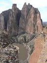
Colliding Rivers
is a nice but small area (only about twenty feet
long and fifteen feet tall) right next to the
where the Little River and the North Umpqua
meet. The only practical time to climb
there is during the summer, since you have to
cross the river to get to it.
Collier Boulders
is a new area. There is no real trail yet
but there are 5-6 huge boulders with routes all
over.
Crater Lake
has lots of unclimbed single pitch rocks on it's
highest peak, Mt. Scott. There is also a few
obscure slab climbs. Enter from the
south on HWY 62 or the north on 138.
Emigrant
Lake has about 20
climbs in all, located towards the north end of
the lake. Enter the main entrance of
park, follow road around to RV parking, look for
big gravel pullout with a cable locked road
behind it. Follow the road around to the
left, you can't miss the rocks!
Greensprings
crag offers about 30 routes near Ashland.
From I-5 exit 14 Ashland, drive east on Hwy 66
Greensprings Hwy toward Klamath Falls. Drive for
about 20 minutes then turn right on Tyler Cr.
Dr. Drive down the gravel road for about 1/4-1/2
mile then park on the pullout on the right. The
approach trail is on the left.
Hot Hot Boulders
has about 4 main boulders next to the road.
There are only a couple of routes so far.
Go North on 97 leaving Klamath Falls, about 5
miles or so you will see a sign to Hagelstein
Park. There is another road just past the road
to the park, a steep forest service road. Take
this road all the way to get to the first split
in the road. There will is BIG pullout spot on
your left, park there. The Boulders will be
in plain view.
John Boyle Res.
From where Hwy 97, 66, and 140 cross, go east
on 66 for 15 miles. Cross over the bridge and
turn left into a day use area next to the water.
Park and follow the road/trail by foot along the
shores. When you see a little outcrop of
rocks right next to the lake, you can either
hike to the top and scramble down, or if the
lake is low enough you can walk on the shore.
The first rock that has been cleaned is Swift
Rock.
Old Man and Old Woman
are close to Glide. Old Man is a spire
next to the North Umpqua River. Old Woman sits
just uphill.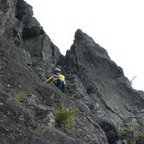
Pilot Rock
is a shallow intrusive rhyolitic volcano plug
that sits on top of the Siskiyous. Loose columns
and loose rock on top have limited most of the
route development on only a small area on the
south side and two earlier routes on the
southwest side. From the top you will have
spectacular views of Mt McLoughlin and Mt
Shasta. Take exit 6 from the I-5
freeway. Follow 99 past the Mt. Ashland turnoff
and continue under the freeway. Three miles
later turn off onto the Pilot Rock Road to the
left. Follow the road 2-3 miles until you reach
the trailhead.
Rattlesnake Crags
offers good, steep climbing on very grippy
welded tuff. Reminiscent of Smith Rock climbs.
Lots of trees though and watch out for Poison
Oak. Must have guide book and a good sense
of direction too or someone who has been there
more than once as it is very secluded.
Williamson Cliffs
were found around the 1970's and overlook the
Williamson River. You may climb here year
round. There are about 10 different walls
each with about 6 to 10 climbs on them. The
cliffs are about a 1/4 mile long and have 95+
routes.
Youtlkut Pillars
is a volcanic feature made up of many vertical
pillars. This crag consists of a face 100
feet long and 70 to 150 feet high.
Smith Rock
Picnic Lunch Wall Area
is the first wall you encounter after the
bridge. It is comprised of three walls. Picnic
lunch Wall which is the first wall. Shiprock is
the second and finally Table Scraps wall.
The Wooden Ships-The Gullies.
After the Picnic Lunch Wall you encounter the
Wooden Ships and the Gullies. Going from east to
west you have Shipwreck Wall, Aggro Wall,
Plastic Area, Honeycomb Wall, West Ship-River
Face, Cocaine Wall, Tuff Nuggets Wall, Aggro
Gully and finally Cocaine Gully.
Morning Glory Wall Area
offers high quality lines just left (west) of
the Wooden Ships/The Gullies. It consists from
left to right (east to west) of Rolling Stone
Wall, Churning Buttress, Overboard Area, Zebra
Area, the Peanut, Fourth Horseman
The Dihedrals
are the great wall facing south so it is hot
during the day. 150 feet long 200 feet high. It
moves from right to left and has some of the
hardest routes in the park.
Christian Brothers
- East Side. It is the wall to the right
of asterisk pass when in the Parking lot.
This wall gets a lot of sun and heat in the
morning until about noon.
Smith Rock Group
is a massive complex of 12 walls.
West Side Crags
are the backside of Smith Rock when looking from
the parking lot. The sections are called
Angel Flight Crags, Christian Brothers - West
Side, Mesa Verde Wall, Pleasure Palace, Snake
Rock , and Spiderman Buttress.
Monkey Face Area
is a free standing 400 foot high spire featuring
outstanding rock. It holds a famous high line
and the "Pioneer Route", one of the 50 classics.
Red Wall.
From the footbridge follow the sign and go up
and right. This area is shady in the afternoon.
Brogan Spire Complex
is part of the Marsupials. It is a fairly long
approach. The area has recently seen some
development.
Delerium Tremens
has good rock with an outstanding crack line on
it.
Marsupial bouldering.
Take the trail to the Marsupial crags, continue
till you run into the rim rocks, walk up hill
till you come onto the rode for the tunnel,
continue towards wombat area.
Smithrock bouldering fields 1 & 2,
some of the best bouldering and projects
around..
Mini Half Dome
is a block below the lowest point of Brogan
Spire. It resembles Half Dome.
Tasmanian Devil
is a pillar of decent rock.
The Wombat.
Most of the rock here is no good, but there are
some good climbs if you look closely.
Northern Point
is a 50 foot basalt cliff with a very short
approach from the turn-around parking lot.
Numerous climbs on solid basalt, with sport,
crack, and top-rope climbing.
Student wall
is a great spot to bring beginners at Smith. It
is away from the crowds and has a great view of
the gorge. It is one of the few top rope
accessible areas and it has some stout routes
close by.
Lower Gorge
has bolted lines, the highest quality routes in
the lower gorge are trad. If you like crack
climbing, come here!
Upper Gorge
is mostly high end sport routes on perfect rock.
There are beautiful columns with no crowds.
Bivy Bouldering
has 10 boulders located below the Bivy area.
There is one 20 ft over hanging cliff with top
rope ancrers on the rim. To reach the boulders
cut down sooner than the normal trail to the
canyon. The rock is tuff not basalt rim.
Mudpile
has unique rock, unlike anything else at Smith.
Here you can climb on volcanic tufas,
honeycombed mud, and ultra-steep cave routes.
The left and right sides of the formation
contain mostly vertical to less than vertical
moderates. The cave in the center contains steep
routes ranging from 5.12 to 5.14
Skull Hollow Campground is behind Smith Rock
State Park in Terrebonne is a town called Lone
Pine, on Lone Pine Rd. Past the town is a free
campground called Skull Hollow Campground.
|